Currently Browsing: Maps

Gil Cedillo running for Council District 1 seat

CD1 borders in Echo Park

Looks like we’ve got another candidate for the First District of the LA City Council – Gil Cedillo announced his aspirations two days ago in a press release to fill the seat of soon-to-be termed-out Ed Reyes in the 2013 elections, joining Reyes’ chief of staff Jose Gardea. Cedillo is currently our state assemblyman in the 45th district, a seat which he can’t run for again due to term limits.

Cedillo has a couple of good things going for him, including the California Dream Act, which was recently signed by the Governor. We also saw him rubbing elbows with the general public and press in September at a Northeast LA foreclosure fair. Mostly, we hope if he wins the election, he’ll be an involved and responsive representative of the First District, which includes parts of Echo Park, Elysian Park, Highland Park, Mt. Washington, and other surrounding neighborhoods (click here for a full map).

In the press release, Cedillo said he was running “because we need bold and experienced leadership to strengthen and protect the Los Angeles Dream.”

“Gil began his crusade for change and social justice over three decades ago as a young student leader right here in Los Angeles,” said El Centro del Pueblo Executive Director Sandra Figueroa in the press release. “Since those early days, Gil has remained one of the most effective and passionate progressive advocates in Los Angeles.  Now is exactly the time to bring Gil Cedillo’s determined and forceful leadership to City Hall on behalf of the diverse neighborhoods that comprise City Council District 1.”


The changing landscape of Echo Park Lake

Click here for the full map (PDF)

In case you’ve missed it, there are not only covered fences up around Echo Park Lake, but it’s also looking a bit… lower now. That’s because the rehabilitation project has finally (and sadly) begun – phase one of the draining having started at the end of August, pumping about eight feet of water out of the lake and into the storm drains.

The temporary pools have been installed, and with all the muck in the lake water already it seems the wildlife is taking advantage. The fish and other water wildlife (turtles, etc.) will be relocated once the lake has been drained a few feet (supervised by a wildlife biologist), after which the lake will be completely drained and the Odor Monitoring Group will be called upon to monitor.

After a July 20, 2011 Echo Park Lake Rehab public meeting, a couple of improvements were made after residents spoke up:

  1. A portion of the sidewalk on the west side of the lake along Glendale Boulevard will be closed after residents complained the sidewalk was too narrow, and thus dangerous, for pedestrian use. They will install alternate route signs.
  2. Parking restrictions along Echo Park Avenue have been slightly relieved – instead of No Parking between 6:00 am to 6:00 pm, it’s 7:00 am to 5:00 pm. Residents more recently pointed out that the parking isn’t even being used by construction workers. According to one resident, who contacted the project managers, the parking will be used by construction workers since the Lady of the Lake statue was removed (apparently she was in the way of construction access).

(more…)


Just head north through… Enendale?

Bing Maps has us scratching our heads when we searched for our Echo Park neighborhood. Is “Enendale” code for something? Last we checked the historical name for the area is Edendale, but even that isn’t really used. Does Bing know something we don’t know…?


Map: How walkable is Echo Park?

Apparently, very walkable!

With an average “walk score” of 75, Echo Park is #19 of 95 neighborhoods scored by the website walkscore.com. The green highlights in the map shown above indicate a high walkability zone (where “daily errands do not require a car”), while the red areas are less walkable (where “almost all errands require a car”).

Now, we love the walking thing – in a beautiful neighborhood like Echo Park, it’s wonderful, free exercise and we get to explore the many hidden stairways.

You may notice that the map, however, doesn’t show ALL of Echo park, missing the neighborhoods west of Alvarado and south of the 101, but you get the picture.

Click here to check out the full map and details from the Walk Score website.


Zooming in on Echo Park: 1906 transit map

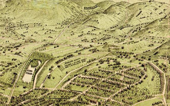
Another great post by The Big Map Blog recently shows a map of Los Angeles’ 1906 railway systems. Those systems weren’t lacking in Echo Park, so we’ve zoomed in on the BIG map to show you a little bit of our ‘hood back in the day.

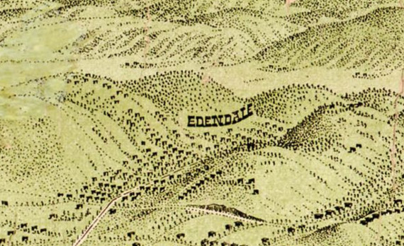
The Glendale Line, which you can see in green, is a” Los Angeles Inter-Urban RY Co.” line that took people between Glendale and Downtown, and possibly even up to Burbank. The Glendale Line ceased to run in June of 1955. The path made by the Glendale line went past Echo Park Lake on the west side of the lake, through “Edendale” and then they had to cut through the hills creating what was known as the “Edendale Cut” (where the 2 freeway is now) and next to Max Sennett’s studio.

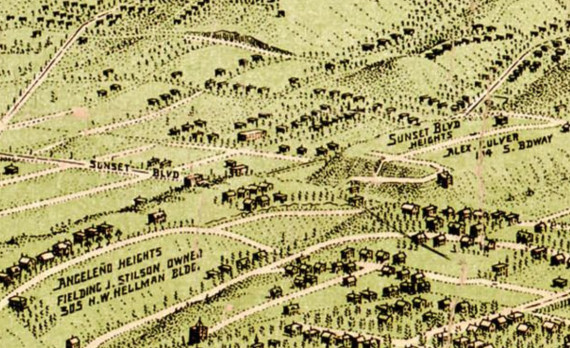
The black lines, which you can see going along Sunset Boulevard then up Echo Park Avenue, were the “Los Angeles Pacific R.R.” There’s an old Three Stooges episode of note that shows Echo Park Avenue and the old railway tracks on the road, and you’ll note a lot of existing stairways in this area so that people could easily access the trains from their hilltop homes.

The red lines note the path for the “Pacific Electric Railway Co.” lines, which on the east side of the Los Angeles River took passengers up to Highland Park and beyond to Pasadena.

And finally, yellow – the “Los Angeles RY. Co.” lines, which had a lot of lines into East Los Angeles and up into what is now Elysian Valley.

However, apart from probably different sized trains between each line, I’m not certain on what the exact difference was between each company that handled the different lines. LA Taco has a little more insight on the matter:

At that point, LA was an underdeveloped but rapidly growing city, and rail was the dominant form of intra-city transportation. The yellow and red lines on the map show the two main competing streetcar systems, Los Angeles Railway (Yellow Cars) and Pacific Electric Railways (Red Cars). At this point, both systems were only 5 years old. The Yellow Cars carried more daily riders, but the Red Cars extended farther from the downtown hub. At the height of the Yellow Car’s operations, the system had 20 streetcar lines and 1,250 trolleys, and served the core of LA in addition to Echo Park, Westlake, Hancock Park, Exposition Park, West Adams, the Crenshaw district, Vernon, Boyle Heights and Lincoln Heights.

Either way, it’s disappointing that in the mid-50s and into the 1960s and ’70s these tracks were being dismantled. Surely there were politics, power and money involved, but you also can’t help but think about the emerging car culture in those times. People were probably more keen on that new Mustang than getting on a dusty old red car!

Click here to download the full map or visit the Big Map Blog website.


Fallen Fruit of Echo Park video/commercial

This is a really cute commercial/advertisement featuring the Fallen Fruit guys on their search for public fruit in Echo Park. Though not all of the shots are Echo Park itself, you can see them building the map of Fallen Fruit in Echo Park using social media and other technologies, specifically this “Samsung Galaxy Tab” device and what looks to be similar to the iPad.

While we haven’t find the Echo Park map on the Echo Park map on the Fallen Fruit website yet, we’re sure it will pop up soon. Based on an old map it had a while back (click here to view that map) we started a while back creating a map of our own. Some items may be outdated, and we are slowly building more of the map, but that’s why you’re going to let us know if we’ve missed anything using the comments field below.

View Echo Park Fallen Fruit Trees in a larger map


« Previous Entries

Powered by WordPress | Designed by Elegant Themes