Zooming in on Echo Park: 1906 transit map
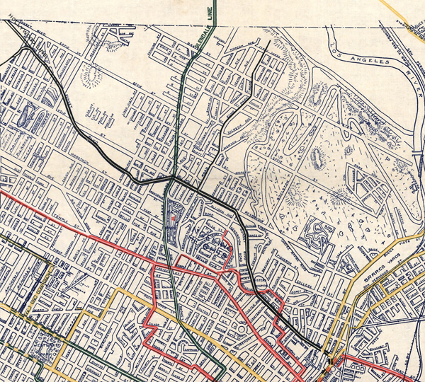
 Another great post by The Big Map Blog recently shows a map of Los Angeles’ 1906 railway systems. Those systems weren’t lacking in Echo Park, so we’ve zoomed in on the BIG map to show you a little bit of our ‘hood back in the day.
The Glendale Line, which you can see in green, is a” Los Angeles Inter-Urban RY Co.” line that took people between Glendale and Downtown, and possibly even up to Burbank. The Glendale Line ceased to run in June of 1955. The path made by the Glendale line went past Echo Park Lake on the west side of the lake, through “Edendale” and then they had to cut through the hills creating what was known as the “Edendale Cut” (where the 2 freeway is now) and next to Max Sennett’s studio.
The black lines, which you can see going along Sunset Boulevard then up Echo Park Avenue, were the “Los Angeles Pacific R.R.” There’s an old Three Stooges episode of note that shows Echo Park Avenue and the old railway tracks on the road, and you’ll note a lot of existing stairways in this area so that people could easily access the trains from their hilltop homes.
The red lines note the path for the “Pacific Electric Railway Co.” lines, which on the east side of the Los Angeles River took passengers up to Highland Park and beyond to Pasadena.
And finally, yellow – the “Los Angeles RY. Co.” lines, which had a lot of lines into East Los Angeles and up into what is now Elysian Valley.
However, apart from probably different sized trains between each line, I’m not certain on what the exact difference was between each company that handled the different lines. LA Taco has a little more insight on the matter:
At that point, LA was an underdeveloped but rapidly growing city, and rail was the dominant form of intra-city transportation. The yellow and red lines on the map show the two main competing streetcar systems, Los Angeles Railway (Yellow Cars) and Pacific Electric Railways (Red Cars). At this point, both systems were only 5 years old. The Yellow Cars carried more daily riders, but the Red Cars extended farther from the downtown hub. At the height of the Yellow Car’s operations, the system had 20 streetcar lines and 1,250 trolleys, and served the core of LA in addition to Echo Park, Westlake, Hancock Park, Exposition Park, West Adams, the Crenshaw district, Vernon, Boyle Heights and Lincoln Heights.
Either way, it’s disappointing that in the mid-50s and into the 1960s and ’70s these tracks were being dismantled. Surely there were politics, power and money involved, but you also can’t help but think about the emerging car culture in those times. People were probably more keen on that new Mustang than getting on a dusty old red car!
Click here to download the full map or visit the Big Map Blog website.

It’s hard to come by educated people on this topic, but you seem like you know what you’re talking about! Thanks
Good site you have here.. It’s hard to find excellent writing like yours nowadays. I honestly appreciate individuals like you! Take care!!